Lay of The Land
Geography of the Mason Dixon 1200
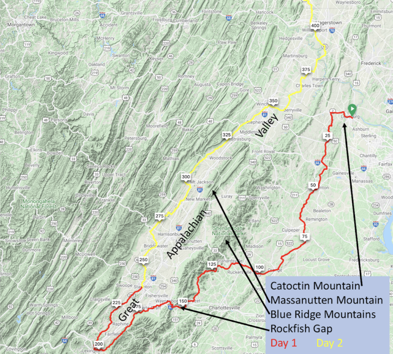
Most of Day 1 takes place on the Virginia Piedmont, or “foot of the mountains.” This is an agricultural region and “Virginia horse country”, replete with rolling hills and ridges.
In the first five miles of the ride you will encounter the easternmost ridge of the Appalachian Mountains as you climb 500 feet to go over Catoctin Mountain and enter the Loudoun Valley. The Presidential retreat Camp David is on this ridge, about 40 miles to the north. This ridge, and the Blue Ridge you will cross later in the day, is made of 570 million-year old magma that rose to fill the gap as the ancient supercontinent of Rodinia rifted apart. The ridge was then thrust upwards 300 million years ago when Africa collided with North America and formed the continent of Pangaea and the future Appalachian Mountains. These once mighty mountains have since been weathered down to their roots.
At mile 151 you will begin the climb over the Blue Ridge Mountains, ultimately passing through Rockfish Gap to enter the Shenandoah Valley. Rockfish Gap is a wind gap, a notch in the Blue Ridge carved by an ancient river that flowed from the Shenandoah Valley when the valley floor was as high or higher than today’s mountains to the east and west. Like the Shenandoah Valley itself, Rockfish Gap was an ancient passage used regularly by Native Americans. Although 1,900 feet high and one of the highest points on our ride, Rockfish Gap affords a relatively easy entry into the Shenandoah.
You will spend the remainder of Day 1 and all of Day 2 in the Great Appalachian Valley, a feature that runs from Canada to Alabama, which has been an advantageous travel route since prehistoric times. In fact, in Virginia and North Carolina settlement of the valley occurred from Europeans traveling south in the valley from the Susquehanna River Gap, which lies to the north of our route. In Virginia it is known as the Shenandoah Valley and the Cumberland Valley in Pennsylvania; our brief transit in Maryland is called the Hagerstown Valley. While riding you will see the Blue Ridge Mountains to your right and the Ridge-and-Valley Appalachian Mountains to your left. The valley floor is fairly flat, consisting of softer rocks that have been weathered over eons. One exception is Massanutten Mountain, which passes to your right on the first half of Day 2. Capped with harder sandstone, Massanutten has withstood weathering to emerge as a series of ridges.
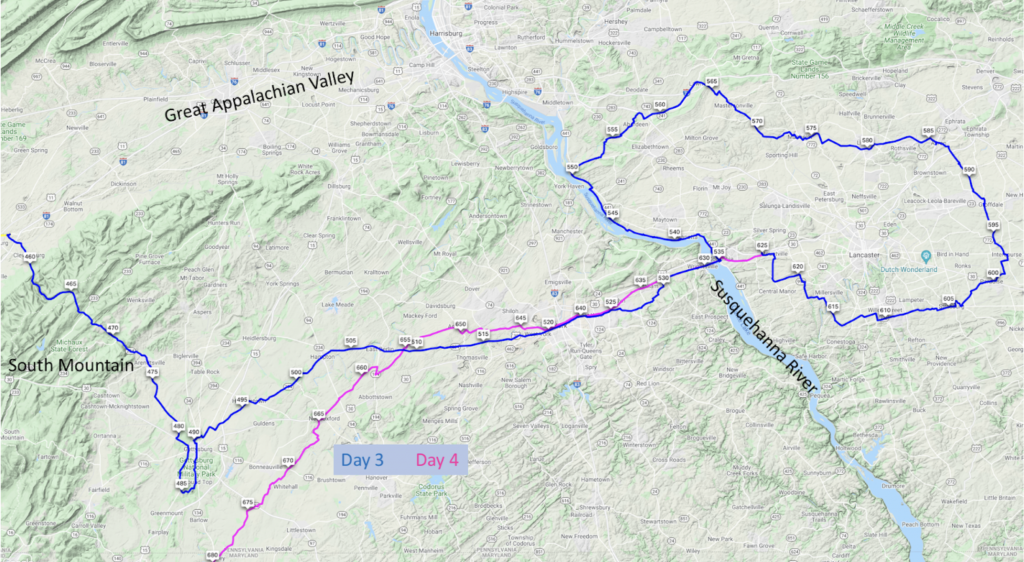
You begin Day 3 with the final significant climb of our ride by exiting the Great Valley over 2,000 foot tall South Mountain, the northernmost part of the Blue Ridge Mountains. From there you will enter the Pennsylvania Piedmont region, also known as Pennsylvania Dutch Country. Later in the day you cross the Susquehanna River, one of the world’s oldest. Evidence of its estimated 300 million year age is the “water gap” you will ride through shortly after crossing it. The ridge has been sliced through by the river. The only way this could have happened is if the river was there before the ridge, with the river slicing through it as the ridge rose.
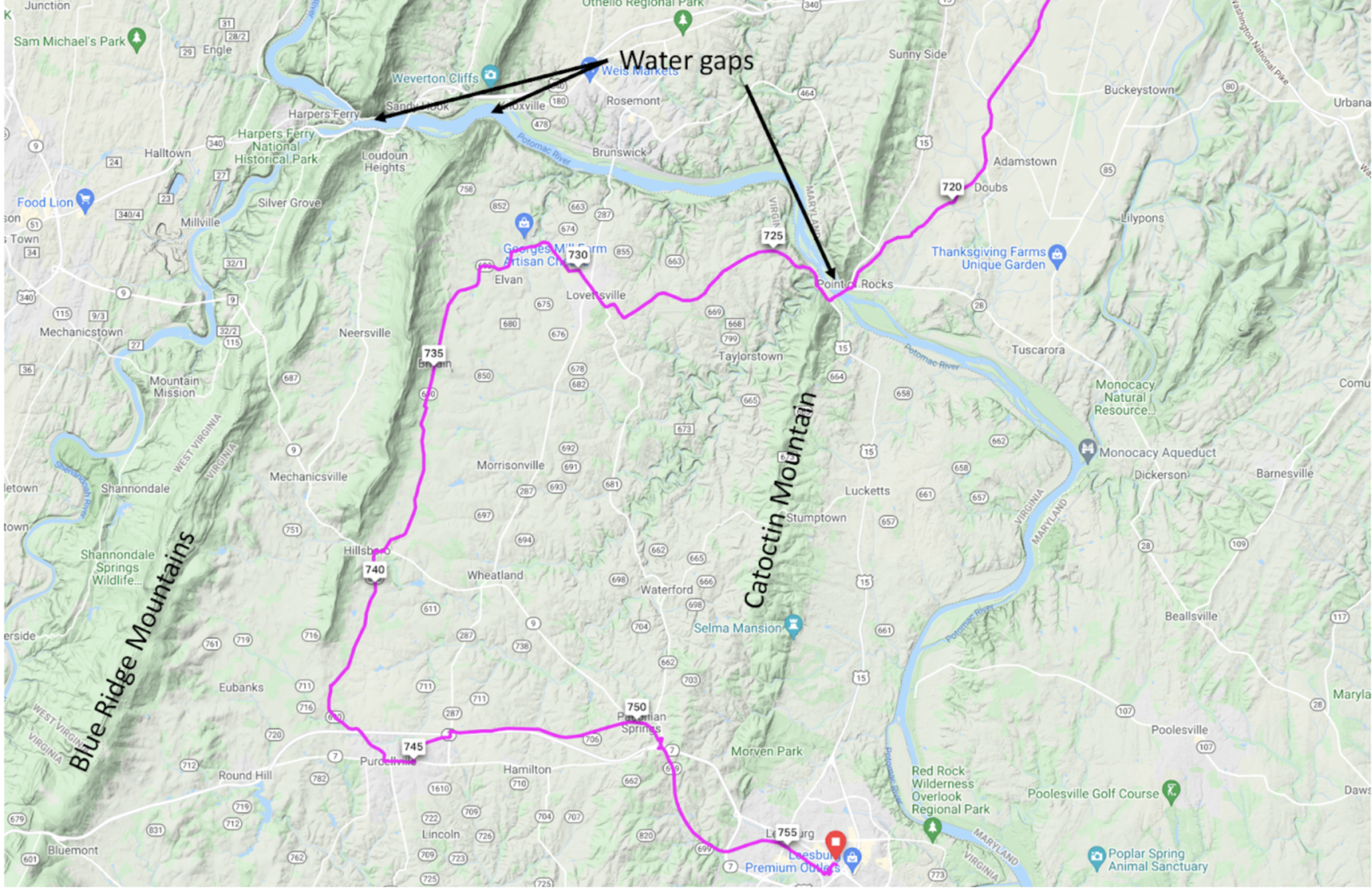
Day 4 crosses the Susquehanna River a second time, passes through Pennsylvania and Maryland, then enters Virginia by crossing the Potomac River (and Catoctin Mountain) at Point of Rocks, a water gap in Catoctin Mountain. The relatively easy climb up from the Potomac over Catoctin provides the day’s biggest climb, and then delivers us back to the Loudoun Valley where the Mason-Dixon 1200 started.


